$1,099,900

 By car (off-peak)



Sold
743 Keefer Street, Vancouver, BC
0
sqft

6175 Commercial Street, Vancouver, British Columbia V5P 3P2

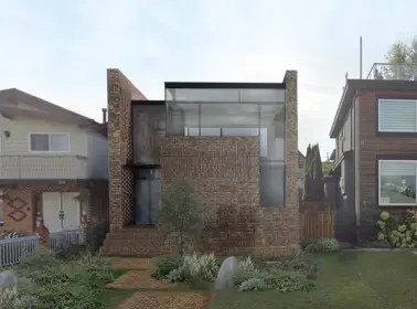
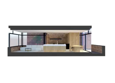
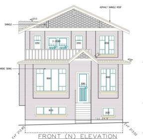
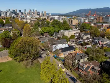
Very quiet and desirable neighbourhood with good schools. Walking distance to the vibrant Victoria Drive. A beautiful level lot to build your dream home. 33 x 97 feet deep with vehicle access from the front entrance for easy access and convenience. 2026 assessed over $1.35mil and tremendous value in this lot. Call before it is gone. Vacant lot. Ready for you to build on it.
| Structures | Land Only |
|---|
| Price | $1,059,900 |
|---|---|
| Property Type | Land |
| Ownership Type | Freehold NonStrata |
| Utility Type | Sanitary Sewer Available, Storm Sewer Available, Electricity Available, Natural Gas Available, Natural Gas Connected, Cable Connected |
| Water (WaterSource) | Public |
| Lot Size | 3204 |
|---|---|
| Lot Size Depth | Feet |
| Lot Size Frontage | 33 |
| MLS® # | R3086338 |
| Area | Vancouver East |
| Neighbourhood | Killarney VE |
| City | Vancouver |
| Postal Code | V5P 3P2 |
| Gross Taxes | $6,852.76 |
| Zoning | R1-1 |
Listed by: Grand Central Realty
NOTE: This representation is based in whole or in part on data generated by the Chilliwack & District Real Estate Board, Fraser Valley Real Estate Board or Greater Vancouver REALTORS® which assumes no responsibility for its accuracy.
Public Schools
Information includes BC Government Open License data; school details change often and are offered solely as general guidance.
Private Schools
Closest Transit
Crime Rate
Demographics
Noise/ Power Lines
Other
6175 Commercial Street has a sell-speed score of 74/100, placing it in the "Expected to sell within weeks" band. The listing is priced 41.1% below comparable active properties in Killarney VE, which is a strong competitive signal. Based on these signals, EstateBlock predicts this listing is likely to sell within a few weeks.
Natural hazards vary by location and can change over time. The following provides a summary of potential impacts to this area, postal code V5P 3P2, over the next 30 years. Projections use the 2041–2070 period (2050s) under a moderate emissions scenario (SSP2-4.5).
Outside of designated flood hazard zones. Under 10% of buildings in this area have flood risk over the next 30 years.
Located within the "Vancouver" WUI zone (Risk Class 5 — Low). Based on BC Wildfire Service provincial WUI Risk Class mapping; not a site-specific assessment.
Annual avg PM2.5 5.1 µg/m³ — meets Canada's CAAQS. Nearest station: Vancouver Clark Drive, Vancouver (~3.6 km). Annual avg AQHI 2.2 — Low Risk.
Vancouver currently sees ~1 day above 30 °C per year (1981–2010 baseline), projected to rise to ~6 by the 2050s (SSP2-4.5 moderate emissions). Hottest day of the year: ~29.7 °C baseline, ~32 °C projected. Tropical nights (>18 °C): ~0 baseline, ~4 projected.
Annual precipitation ~1515 mm (1981–2010 baseline), projected ~1575 mm by the 2050s. Extreme 1-day rainfall: ~50.5 mm baseline, ~57 mm projected. Values vary modestly across the Lower Mainland.
Longest annual dry spell (consecutive dry days): ~22 days baseline, ~24 days projected for the 2050s. CDD is used as a regional drought proxy; drought risk varies modestly across the Lower Mainland.


39 Schools are within 3km
| School | Type | Grades Served | Catchment Info | Rating | Distance |
|---|---|---|---|---|---|
Tecumseh Elementary School |
Public |
Grades ServedK-7
|
Catchment InfoIn Catchment
|
Distance389 m
|
|
Sir Sandford Fleming Elementary School |
Public |
Grades ServedK-7
|
Catchment Info—
|
Distance600 m
|
|
Corpus Christi School |
Independent |
Grades ServedK-7
|
Catchment Info—
|
Distance756 m
|
|
David Thompson Secondary School |
Public |
Grades Served8-12
|
Catchment InfoIn Catchment
|
Distance778 m
|
|
Qawsain Knowledge House |
Independent |
Grades ServedK-3
|
Catchment Info—
|
Distance927 m
|
|
Waverley Elementary School |
Public |
Grades ServedK-7
|
Catchment Info—
|
Distance939 m
|
|
Tecumseh Annex |
Public |
Grades ServedK-3
|
Catchment InfoIn Catchment
|
Distance1.08 KM
|
|
Sir Charles Kingsford-Smith |
Public |
Grades Served—
|
Catchment Info—
|
Distance1.20 KM
|
|
Sir Charles Kingsford-Smith School |
Public |
Grades ServedK-7
|
Catchment Info—
|
Distance1.21 KM
|
|
G. T. Cunningham Elementary School |
Public |
Grades ServedK-7
|
Catchment Info—
|
Distance1.25 KM
|
|
Sir James Douglas Elementary School |
Public |
Grades ServedK-7
|
Catchment Info—
|
Distance1.36 KM
|
|
Sir Alexander Mackenzie Elementary School |
Public |
Grades ServedK-7
|
Catchment Info—
|
Distance1.41 KM
|
|
Sir James Douglas Annex |
Public |
Grades ServedK-3
|
Catchment Info—
|
Distance1.50 KM
|
|
Killarney Secondary School |
Public |
Grades Served8-12
|
Catchment Info—
|
Distance1.77 KM
|
|
David Oppenheimer Elementary School |
Public |
Grades ServedK-7
|
Catchment Info—
|
Distance1.78 KM
|
|
Walter Moberly Elementary School |
Public |
Grades ServedK-7
|
Catchment Info—
|
Distance1.79 KM
|
|
Sir Richard McBride Elementary School |
Public |
Grades ServedK-7
|
Catchment Info—
|
Distance1.85 KM
|
|
John Oliver Secondary School |
Public |
Grades Served8-12
|
Catchment Info—
|
Distance1.89 KM
|
|
Lord Selkirk Annex |
Public |
Grades ServedK-4
|
Catchment Info—
|
Distance1.94 KM
|
|
Anne-Hebert |
Public |
Grades Served—
|
Catchment Info—
|
Distance1.94 KM
|
|
Sir Richard McBride Annex |
Public |
Grades ServedK-3
|
Catchment Info—
|
Distance1.95 KM
|
|
St Andrew's |
Independent |
Grades Served—
|
Catchment Info—
|
Distance1.97 KM
|
|
St. Andrew's |
Independent |
Grades ServedK-7
|
Catchment Info—
|
Distance1.98 KM
|
|
John Henderson Elementary School |
Public |
Grades ServedK-7
|
Catchment Info—
|
Distance2.01 KM
|
|
John Norquay Elementary School |
Public |
Grades ServedK-7
|
Catchment Info—
|
Distance2.02 KM
|
|
Gladstone Secondary |
Public |
Grades Served—
|
Catchment Info—
|
Distance2.32 KM
|
|
Gladstone Secondary School |
Public |
Grades Served8-12
|
Catchment Info—
|
Distance2.34 KM
|
|
Lord Selkirk Elementary School |
Public |
Grades ServedK-7
|
Catchment Info—
|
Distance2.40 KM
|
|
Pierre Elliott Trudeau Elementary School |
Public |
Grades ServedK-7
|
Catchment Info—
|
Distance2.54 KM
|
|
Captain James Cook Elementary School |
Public |
Grades ServedK-7
|
Catchment Info—
|
Distance2.59 KM
|
|
Charles Dickens Annex |
Public |
Grades ServedK-3
|
Catchment Info—
|
Distance2.67 KM
|
|
General Brock Elementary School |
Public |
Grades ServedK-7
|
Catchment Info—
|
Distance2.75 KM
|
|
Dr. H. N. MacCorkindale Elementary School |
Public |
Grades ServedK-7
|
Catchment Info—
|
Distance2.77 KM
|
|
Sir Wm Van Horne Elementary School |
Public |
Grades ServedK-7
|
Catchment Info—
|
Distance2.77 KM
|
|
Collingwood Neighbourhood School |
Public |
Grades ServedK-3
|
Catchment Info—
|
Distance2.80 KM
|
|
Tyee Elementary School |
Public |
Grades ServedK-7
|
Catchment Info—
|
Distance2.85 KM
|
|
Lord Beaconsfield Elementary School |
Public |
Grades ServedK-7
|
Catchment Info—
|
Distance2.90 KM
|
|
Sir Wilfred Grenfell Community |
Public |
Grades Served—
|
Catchment Info—
|
Distance2.98 KM
|
|
Sir Wilfred Grenfell Community School |
Public |
Grades ServedK-7
|
Catchment Info—
|
Distance2.99 KM
|
Calculate your commute
6175 Commercial St, Vancouver, BC is ideally located for commuters. The property is 2.4 km from 29th Ave, with a 45 min SkyTrain ride to Downtown Vancouver (Waterfront Station). The closest bus stop is Northbound Victoria Dr @ Waverley Ave (0.23 km). Walk Score Transit rating: Good Transit (65/100).


| Year | Land | Improvements | Total Assessed | YOY Change |
|---|---|---|---|---|
| 2026 | $1,332,000 | $22,800 | $1,354,800 |
-5.9%
|
| 2025 | $1,413,000 | $26,500 | $1,439,500 |
+0.7%
|
| 2024 | $1,407,000 | $22,900 | $1,429,900 |
+2.1%
|
| 2023 | $1,377,000 | $23,600 | $1,400,600 |
+7.5%
|
| 2022 | $1,279,000 | $24,000 | $1,303,000 | — |
Buy Vs Rent Calculator
Rent vs own
—
Comparable data is unavailable at the neighbourhood level. City-wide in Vancouver, similar properties average $1,798,667 across 4 active listings — this listing is 41.1% below the Vancouver average. This property is flagged as a Hot Deal (41.1% cheaper than comparables) based on its competitive pricing and market demand.

Potential Cashback for this listing if you buy with us
to track your cashback progress
Buy with us & save on this property
$1,268,000
 11.6% price reduction
$1,050,000
$1,298,000
$948,000