
6060 9th Ave, Burnaby BC V3N 2T5 – Land for Sale – MLS® R3180526
6060 9th Avenue, Burnaby, British Columbia V3N 2T5
Photo

Property Details for 6060 9th Avenue
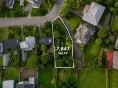
RARE BIG BEND LAND OPPORTUNITY! Discover this substantial 14,800 sq. ft. freehold property in South Burnaby, offering an exceptional setting for buyers exploring a custom-building project, agricultural uses or a long-term landholding. Located in Burnaby's distinctive Big Bend neighbourhood, with convenient access to Market Crossing, Riverway Golf Course, Metrotown, 22nd Street SkyTrain Station and major commuter routes. Architectural building plans are reported available, along with previous site-preparation and technical work for buyer review. The property offers an opportunity to explore future possibilities under the applicable A1 agricultural zoning and municipal requirements.
Exterior Features
| Structures | Land Only |
|---|
Building Details
| Price | $1,188,888 |
|---|---|
| Property Type | Land |
| Ownership Type | Freehold NonStrata |
| Utility Type | Sanitary Sewer Not Available, Storm Sewer Not Available, Electricity Nearby, Natural Gas Not Available, Phone Nearby, Cable Not Available |
| Water (WaterSource) | None |
Lot & Land
| Lot Size | 14800 |
|---|---|
| Lot Size Depth | Feet |
| Lot Size Frontage | 125 |
| MLS® # | R3180526 |
| Area | Burnaby South |
| Neighbourhood | Big Bend |
| City | Burnaby |
| Postal Code | V3N 2T5 |
| Gross Taxes | $3,161.58 |
| Zoning | A1 |
Property Timeline
Listed by: eXp Realty
NOTE: This representation is based in whole or in part on data generated by the Chilliwack & District Real Estate Board, Fraser Valley Real Estate Board or Greater Vancouver REALTORS® which assumes no responsibility for its accuracy.
Map & Neighbourhood
Public Schools
- Elementary
- Glenwood Elementary School
- Average 1.54 km
Information includes BC Government Open License data; school details change often and are offered solely as general guidance.
Private Schools
- Elementary
- Our Lady of Mercy
- Above Average 0.24 km
- Secondary
- St. Thomas More Collegiate
- Above Average 2.81 km
Closest Transit
- Bus Stop
- Southbound Willard St @ 9th Ave
- 0.17 km
- Skytrain
- Skytrain @ 22Nd St Stn
- 1.17 km
Crime Rate
- Total Crime Rate
- Below Average
- Violent Crime Rate
- Low
- Property Crime Rate
- Average
Demographics
- Post-Secondary Education
- Below Average 26%
- No Certificate/Degree
- Above Average 17.2%
- Owner Occupied
- Below Average 55.2%
- Employment Rate
- Above Average 69.4%
Noise/ Power Lines
- Road/Hwy Noise
- Possible
- Railway/Sky train Noise
- Unlikely
- Airport/Port Noise
- Unlikely
- Close to major Power Lines
- Unlikely
Other
- Agricultural Land Reserve (ALR)
- Unlikely
- Flood Area
- Unlikely
- Close to Cemeteries
- Unlikely
Sell Speed & Competition
6060 9th Avenue has a sell-speed score of 66/100, placing it in the "Expected to sell within weeks" band. The listing is priced 69.8% below comparable active properties in Big Bend, which is a strong competitive signal. The local market is currently a Buyer's Market with a sales-to-active ratio of 8.1% and an area average of 46 days on market — buyers have more leverage. With only 198 competing homes currently listed, this property has significant competition. Based on these signals, EstateBlock predicts this listing is likely to sell within a few weeks.
Climate Risk for V3N 2T5
Natural hazards vary by location and can change over time. The following provides a summary of potential impacts to this area, postal code V3N 2T5, over the next 30 years. Projections use the 2041–2070 period (2050s) under a moderate emissions scenario (SSP2-4.5).
Outside of designated flood hazard zones. Under 10% of buildings in this area have flood risk over the next 30 years.
Located within the "Vancouver" WUI zone (Risk Class 5 — Low). Based on BC Wildfire Service provincial WUI Risk Class mapping; not a site-specific assessment.
Annual avg PM2.5 4.4 µg/m³ — meets WHO 2021 guideline. Nearest station: Burnaby South, Burnaby (~2.6 km). Annual avg AQHI 2.2 — Low Risk.
Burnaby currently sees ~1 day above 30 °C per year (1981–2010 baseline), projected to rise to ~7 by the 2050s (SSP2-4.5 moderate emissions). Hottest day of the year: ~30 °C baseline, ~32.4 °C projected. Tropical nights (>18 °C): ~0 baseline, ~3 projected.
Annual precipitation ~1393 mm (1981–2010 baseline), projected ~1445 mm by the 2050s. Extreme 1-day rainfall: ~47.8 mm baseline, ~53.3 mm projected. Values vary modestly across the Lower Mainland.
Longest annual dry spell (consecutive dry days): ~24 days baseline, ~25 days projected for the 2050s. CDD is used as a regional drought proxy; drought risk varies modestly across the Lower Mainland.
Nearby Restaurants, Cafes & Shops

Restaurants (2 nearby)
- Boston pizza · 812 m · Restaurant
- White spot · 993 m · Restaurant

Cafes (2 nearby)
- Conte store & deli · 682 m · Cafe
- Jj bean · 835 m · Cafe

Groceries (1 nearby)
- Sungiven foods · 862 m · Supermarket

Shopping (1 nearby)
- Winners · 915 m · Department Store

Transit (1 nearby)
- Bus stop eastbound southridge dr @ 6600 block · 981 m · Transit
Schools NearBy
16 Schools are within 3km
| School | Type | Grades Served | Catchment Info | Rating | Distance |
|---|---|---|---|---|---|
Our Lady of Mercy |
Independent |
Grades Served—
|
Catchment Info—
|
Distance244 m
|
|
Connaught Heights Elementary |
Public |
Grades Served—
|
Catchment Info—
|
Distance951 m
|
|
Taylor Park Elementary School |
Public |
Grades ServedK-7
|
Catchment Info—
|
Distance1.24 KM
|
|
Glenwood Elementary School |
Public |
Grades ServedK-7
|
Catchment InfoIn Catchment
|
Distance1.54 KM
|
|
Lord Tweedsmuir Elementary |
Public |
Grades Served—
|
Catchment Info—
|
Distance1.79 KM
|
|
Fraser Park Secondary School Program |
Public |
Grades Served—
|
Catchment Info—
|
Distance1.95 KM
|
|
Queen Elizabeth Elementary School |
Public |
Grades ServedK-4
|
Catchment Info—
|
Distance1.96 KM
|
|
Clinton Elementary School |
Public |
Grades ServedK-7
|
Catchment Info—
|
Distance2.09 KM
|
|
Queensborough Middle School |
Public |
Grades Served5-8
|
Catchment Info—
|
Distance2.16 KM
|
|
Hamilton Elementary |
Public |
Grades Served—
|
Catchment Info—
|
Distance2.27 KM
|
|
St. Francis de Sales |
Independent |
Grades ServedK-7
|
Catchment Info—
|
Distance2.63 KM
|
|
Burnaby South Secondary |
Public |
Grades Served—
|
Catchment Info—
|
Distance2.69 KM
|
|
St. Thomas More Collegiate |
Independent |
Grades Served—
|
Catchment Info—
|
Distance2.81 KM
|
|
Windsor Elementary School |
Public |
Grades ServedK-7
|
Catchment Info—
|
Distance2.91 KM
|
|
Lord Kelvin Elementary School |
Public |
Grades ServedK-5
|
Catchment Info—
|
Distance2.91 KM
|
|
John Knox Christian - Secondary Campus |
Independent |
Grades Served—
|
Catchment Info—
|
Distance2.93 KM
|
Pre-computed routes from 6060 9th Ave, Burnaby, BC

By transit (Skytrain)
-
Downtown Vancouver via 22nd Street → Waterfront42 min
-
Metrotown, Burnaby via 22nd Street → Metrotown24 min
-
SFU Burnaby via 22nd Street → Production Way30 min
-
Richmond Centre via 22nd Street → Brighouse67 min
-
YVR Airport via 22nd Street → YVR-Airport68 min
By car (off-peak)
 By car (off-peak)
-
Downtown Vancouver via HWY 1 / Grandview18 min
-
Metrotown, Burnaby via Lougheed Hwy5 min
-
SFU Burnaby via Gaglardi Way9 min
-
Richmond Centre via No. 3 Rd16 min
-
YVR Airport via Bridgeport / Sea Island19 min
Calculate your commute
6060 9th Ave, Burnaby, BC is ideally located for commuters. The property is 1.2 km from 22nd Street, with a 42 min SkyTrain ride to Downtown Vancouver (Waterfront Station). The closest bus stop is Southbound Willard St @ 9th Ave (0.17 km). Walk Score Transit rating: Good Transit (67/100).
Walkability & Transit Near 6060 9th Avenue

Walk Score - Car-Dependent

Transit Score - Good Transit

Bikeable 60
Bike Score - Bikeable
Mortgage Calculator for 6060 9th Avenue
Investment Cashflow Calculator
Estateblock Rent Estimate for 6060 9th Avenue, Burnaby
Buy Vs Rent Calculator
Rent vs own
—
Price vs Neighbourhood Average — Big Bend, Burnaby
Comparable data is unavailable at the neighbourhood level. City-wide in Burnaby, similar properties average $3,933,333 across 3 active listings — this listing is 69.8% below the Burnaby average. This property is flagged as a Hot Deal (69.8% cheaper than comparables) based on its competitive pricing and market demand.
Call or Text Now!

Earn Cashback on Your Purchase
Potential Cashback for this listing if you buy with us
to track your cashback progress
Buy with us & save on this property
Similar Land for Sale in Burnaby

$1,499,000
7345 Curtis Street, Burnaby, BC

$1,449,000
7349 Curtis Street, Burnaby, BC

$1,399,000
7353 Curtis Street, Burnaby, BC

$1,499,000
4753 Pender Street, Burnaby, BC
 7.8% price reduction
$1,280,000
7258 Ridge Drive, Burnaby, BC
$1,499,000
11 Hythe Avenue, Burnaby, BC
600-777 Hornby Street, Vancouver, BC V6Z 1S4. Call 778-918-5990.
About EstateBlock · Who reviews our guides
