Sold
6158 152a Street, Surrey, BC
0
sqft

16708 57 Avenue, Surrey, British Columbia V3S 2P1


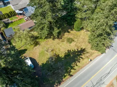
Rare opportunity to build a brand new single family home or a duplex in the prestigious West Cloverdale neighbourhood! This approximately 12,262 sqft lot is fully serviced! This lot is 3 level buildable and is centrally located with all levels of schools, major routes, grocery stores, shopping, rec centres and more minutes away!
| Exterior Features | Private Yard |
|---|---|
| Structures | Land Only |
| Price | $1,249,900 |
|---|---|
| Property Type | Land |
| Ownership Type | Freehold NonStrata |
| Community Features | Near Shopping |
| Utility Type | Sanitary Sewer At Lot Line, Storm Sewer At Lot Line, Electricity At Lot Line, Natural Gas At Lot Line, Natural Gas Connected, Cable Connected |
| Water (WaterSource) | Public |
| Lot Size | 12262 |
|---|---|
| Lot Size Depth | Feet |
| MLS® # | R3176770 |
| Area | Cloverdale |
| Neighbourhood | Cloverdale BC |
| City | Surrey |
| Postal Code | V3S 2P1 |
| Gross Taxes | $5,767.08 |
| Zoning | R2 |
Listed by: Century 21 Coastal Realty Ltd.
NOTE: This representation is based in whole or in part on data generated by the Chilliwack & District Real Estate Board, Fraser Valley Real Estate Board or Greater Vancouver REALTORS® which assumes no responsibility for its accuracy.
Public Schools
Information includes BC Government Open License data; school details change often and are offered solely as general guidance.
Private Schools
Closest Transit
Crime Rate
Demographics
Noise/ Power Lines
Other
16708 57 Avenue has a sell-speed score of 50/100, placing it in the "Expected to sell at a moderate pace" band. The listing is priced 3.8% below comparable active properties in Cloverdale BC, which is a strong competitive signal. Based on these signals, EstateBlock predicts this listing is may take several weeks to attract serious offers.
Natural hazards vary by location and can change over time. The following provides a summary of potential impacts to this area, postal code V3S 2P1, over the next 30 years. Projections use the 2041–2070 period (2050s) under a moderate emissions scenario (SSP2-4.5).
Outside of designated flood hazard zones. Under 10% of buildings in this area have flood risk over the next 30 years.
Located within the "Vancouver" WUI zone (Risk Class 5 — Low). Based on BC Wildfire Service provincial WUI Risk Class mapping; not a site-specific assessment.
Annual avg PM2.5 4.6 µg/m³ — meets WHO 2021 guideline. Nearest station: Surrey East, Surrey (~5.5 km). Annual avg AQHI 1.8 — Low Risk.
Surrey currently sees ~1 day above 30 °C per year (1981–2010 baseline), projected to rise to ~8 by the 2050s (SSP2-4.5 moderate emissions). Hottest day of the year: ~30 °C baseline, ~32.5 °C projected. Tropical nights (>18 °C): ~0 baseline, ~3 projected.
Annual precipitation ~1516 mm (1981–2010 baseline), projected ~1574 mm by the 2050s. Extreme 1-day rainfall: ~51.5 mm baseline, ~57.1 mm projected. Values vary modestly across the Lower Mainland.
Longest annual dry spell (consecutive dry days): ~23 days baseline, ~24 days projected for the 2050s. CDD is used as a regional drought proxy; drought risk varies modestly across the Lower Mainland.


9 Schools are within 3km
| School | Type | Grades Served | Catchment Info | Rating | Distance |
|---|---|---|---|---|---|
Surrey Centre Elementary |
Public |
Grades Served—
|
Catchment Info—
|
Distance376 m
|
|
Surrey Centre Elementary School |
Public |
Grades ServedK-7
|
Catchment InfoIn Catchment
|
Distance383 m
|
|
A J McLellan Elementary |
Public |
Grades Served—
|
Catchment Info—
|
Distance893 m
|
|
George Greenaway Elementary School |
Public |
Grades ServedK-7
|
Catchment Info—
|
Distance1.55 KM
|
|
Cloverdale Catholic School |
Independent |
Grades ServedK-7
|
Catchment Info—
|
Distance1.65 KM
|
|
Cloverdale Learning Centre |
Public |
Grades Served10-12
|
Catchment Info—
|
Distance1.78 KM
|
|
SD 36 Alternate Cloverdale LC |
Public |
Grades Served—
|
Catchment Info—
|
Distance1.88 KM
|
|
Cloverdale Traditional |
Public |
Grades Served—
|
Catchment Info—
|
Distance2.29 KM
|
|
Lord Tweedsmuir Secondary School |
Public |
Grades Served8-12
|
Catchment InfoIn Catchment
|
Distance2.72 KM
|


| Year | Land | Improvements | Total Assessed | YOY Change |
|---|---|---|---|---|
| 2026 | $1,522,000 | $0 | $1,522,000 | — |
Buy Vs Rent Calculator
Rent vs own
—
Comparable data is unavailable at the neighbourhood level. City-wide in Surrey, similar properties average $1,298,689 across 34 active listings — this listing is 3.8% below the Surrey average.

Potential Cashback for this listing if you buy with us
to track your cashback progress
Buy with us & save on this property

$1,099,900
6210 175b Street, Surrey, BC
$1,099,900
6220 175b Street, Surrey, BC
$1,149,000
6320 180 Street, Surrey, BC
$1,099,000
18086 66 Avenue, Surrey, BC 22.6% price reduction
$1,199,900
5582 184 Street, Surrey, BC
$1,199,000
5331 188 Street, Surrey, BC
$1,050,000
18922 62 Avenue, Surrey, BC
$1,050,000
18916 62 Avenue, Surrey, BC 6.4% price reduction
$1,010,000
18998 62 Avenue, Surrey, BC